Your shopping cart is empty!
Airbone Hyperspectral Imaging


Availability: In Stock
Airbone Hyperspectral Imaging
Download Data Sheet
Product Code: ATH9010SXC
application
The ATH9010SXC series UAV-borne early pine nematode inspection system has the characteristics of strong early warning capability, large inspection area, and low cost of use. Especially suitable for forest pest control work.
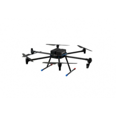
ATH9010SXC is a series of small and lightweight UAV-borne micro-hyperspectral imagers. It consists of a six-rotor high-stability UAV, a high-stability gimbal, a hyperspectral imager, a large-capacity storage system, a wireless image system. It is composed of GPS navigation system, ground receiving workstation, ground control system, etc.
Model | Description |
ATH9010SXC | Multi-rotor drones patrol an area of about 3- 10 square kilometers every day |
ATH9010SXC-FW | Vertical take-off and landing fixed-wing UAV, patrolling an area of about 20- 100 square kilometers every day |
| Optosky Optical Parameters | |
| Frame Rate | 130 Hz |
| Resolution Before Binning | 2048 (spectral dimension) × 2048 (spatial dimension) |
| Resolution After Binning | 512 (spectral dimension) × 2048 (spatial dimension) |
| Optosky Electrical Parameters | |
| Power supply | 12V,15W |
| Storage Temp. | -20 ~ 65℃ |
| Operating Temp. | -10 ~ 45℃ |
| Working humidity | ≤85% RH |
| Interface | USB3.0 |
| Load PC | Intel I7 |
| UAV System | |
| Flying platform | Customized version of long-duration, high-load, large-scale 6-rotor UAV ATH9010SXC-FW: Vertical take-off and landing fixed wing drone |
| Cloud Platform | ATH9010SXC: Three-axis brushless DC motor high stability gimbal ATH9010SXC-FW: Highly stable gimbal |
| Rotor No. | ATH9010SXC: 6 rotors ATH9010SXC-FW: 4 rotors |
| Lift | Take off and land vertically |
| Wheelbase | 1500 mm |
| Max base | ATH9010SXC: 6 Kg ATH9010SXC-FW: 5 Kg |
| Max altitude | ATH9010SXC: 5000 m ATH9010SXC: 100-5000 m |
| Drone size | ATH9010SXC: 1650×1410×500 mm ATH9010SXC-FW: 3.8×1.95 m |
| GPS accuracy | 0.5 m |
| Flight duration | ATH9010SXC: >45 minutes ATH9010SXC-FW: >2 hours |
| Remote change imaging parameter (Y/N) | ATH9010SXC: No ATH9010SXC-FW: Yes |
| Software | |
| Basic Functions | Flexible to set exposure time, gain, speed, dynamic real-time images and curves, and real-time hyperspectral images and hyperspectral curves can be dynamically displayed |
| Focus adjust | Dynamic real-time image obtained through precision focus adjustment can avoid human visual focusing error |
| Software Functions | Data acquire software can real-time shows images and curves; Transmission and reflectance measure mode; Set exposure time, speed in flexible; Standard in-built Library and self-built library; Others like images cut and identify spectrum |
- Using hyperspectral imaging technology, pine nematode damage can be detected early.
- The inspection area is large, and the maximum inspection area can be 100 square kilometers/day.
- High spatial resolution, up to 50mm spatial resolution.
- Flight altitude: 50~ 1000 meters, 100m recommended.
- I7 onboard computer supports up to 2T storage and can store up to 100 hours of map data.
- Equipped tools: Large multi-rotor UAV: 1.5m wheelbase, high load capacity, strong scalability; long flight time of about 45 minutes, large cruising area. Vertical take-off and landing fixed-wing UAV: easy to operate, high load capacity, long flight time of about 2 hours, cruising area up to 100 square kilometers/day.
- Forest disease and fire monitoring
- Pasture Productivity and Pasture Monitoring
- Environmental protection and mine monitoring
What is Hyperspectral Imaging Camera?
Hyperspectral imaging Camera, or imaging spectroscopy, combines the functions of imaging camera and spectroscopy. A hyperspectral camera acquires the spectrum for each pixel in an image of the scenes.
What does Hyperspectral Imaging Camera used for?
Hyperspectral Imaging Camera are used for applications in astronomy, agriculture, molecular biology, biomedical imaging, geosciences, physics, environment,and monitoring. Hyperspectral imaging camera takes pictures of objects spectrum with unique 'fingerprints', it enable identification of the materials. Like spectral fingerprint of oil helps geologists locate new oil fields.
What does Hyperspectral Imaging Camera tell you?
The hyperspectral imaging provides much more color information in details than a normal camera,which leads to differentiate from objects in the scene. Hyperspectral imaging is used to find objects, identify materials, or detect processes.
How much does Hyperspectral Imaging Camera cost?
OPTOSKY manufactures hyperspectral imaging camera 400-1000nm prices range USD45,000~49,800.
How to choose a Hyperspectral Imaging Camera?
Compare FOV,spatial dimensions, weight,optical performance,size, and cost etc.
Where to buy Hyperspectral Imaging Camera?
Buy from local distributor of OPTOSKY,online shopping or inquire us.
Why Chosse Optosky Hyperspectral Imaging Camera?
1.Optosky F2.4, FOV is larger than that of competitors
2.Spatial dimension 14mm
3.Lightweight 1500 g, 950g, 650g
4.High optical performance
5.Compact size:300x70 x70mm;300x60x60mm;270x50x50mm