Your shopping cart is empty!
Multispectral Lidar Drone
Availability: In Stock
Multispectral Lidar Drone
Product Code: ATHL9626
application
Description
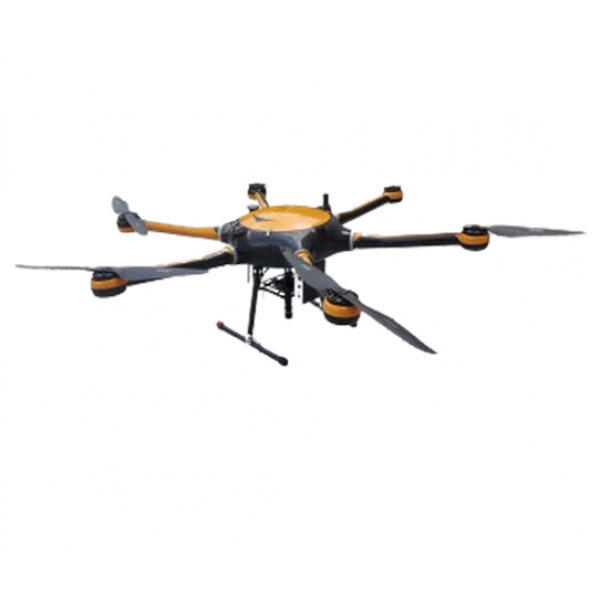
The ATHL9626 Multispectral LiDAR Drone, introduced as Optosky's latest third-generation UAV multispectral imager, integrates a LiDAR module for advanced aerial data collection. This compact and lightweight system includes a stable hexacopter, reliable gimbal system, high-spectral imager, and large-capacity storage, GPS navigation, ground receiving workstation, and control system. Leveraging its multispectral capabilities and line-scan LiDAR, it acquires precise surface elevation data, enabling detailed orthorectification and three-dimensional object feature capture, complemented by spectral analysis for innovative research applications.Featuring a high-resolution solid-state scanning LiDAR module and high-spectral imager, the ATHL9626 generates real-time true-color point clouds, efficiently covering over 2 km² in a single flight. This UAV is ideal for real-time spectral measurement of vegetation, water bodies, soils, and other terrain features, producing detailed spectral images. By correlating spectral data with plant physicochemical properties, it supports applications in precision agriculture, environmental monitoring, and forestry management.Optosky's ATHL9626 Multispectral LiDAR Drone represents a breakthrough in remote sensing technology, catering to the growing demand for high-precision aerial data collection. Its integration of LiDAR and multispectral imaging capabilities positions it as a versatile tool for researchers, agronomists, and environmental scientists seeking comprehensive insights into landscape dynamics and ecosystem health.
Feature
- 5 multispectral lenses & 1 RGB lens.
- 320M & 1230M pixels.
- 12-bit global & 8-bit rolling shutter.
- DJI X-Port control.
- Fastest 1s synchronous imaging across all channels.
- Onboard real-time spectral inversion, video output.
- Standard Downward Light Sensor (DLS).
- Various trigger modes including timing and overlap rate.
- Customizable lenses for different aircraft configurations.
NO. | Index | ATH9626 |
Flight system | flying platform | Customized version of long-term high-load large-scale 6-rotor drone/DJI M300RTK |
PTZ | Three-axis brushless DC motor high stability gimbal | |
Number of rotors | 6 rotors | |
Take-off and landing mode | vertical takeoff and landing | |
Wheelbase | 1500mm | |
Maximum load | 6kg | |
maximum ceiling | 5000m | |
size | 1650*1410*500mm | |
GPS | 1.5m | |
Modify imaging parameters remotely | no | |
Endurance flight time | >45 minutes | |
Ground Station Working Distance | 5km | |
Lidar | Radar mode of operation | TOF time-of-flight ranging |
Laser wavelength | 1550nm, eye safety level 1 | |
Ranging speed | 500,000 points/second, up to 1 million points/second (depending on distance) | |
Number of scan lines | 1750 line | |
field of view | Horizontal 15° | |
Angular resolution | Horizontal 0.009° | |
scanning frequency | 500HZ | |
Height measurement range | 1~300m, up to 600m | |
laser return mode | multiple echoes | |
Height measurement error | <20mm | |
weight | 1.5kg | |
Reliability | range of working temperature | -10 ~ 45℃ |
storage temperature range | -20 ~ 65℃ | |
Working Humidity Range | ≤85% RH | |
Spectral performance | Spectral channel | 450nm@30nm,555nm@27nm,660nm@22nm,720nm@10nm,840nm@30nm,RGB |
coverage width | multispectral:109m×82m@h120m;RGB:2.60cm@h120m | |
ground resolution | multispectral:5.28cm@h120m;RGB:2.60cm@h120m | |
Number of quantization bits | multispectral:12bit;RGB:8bit | |
Imaging lens*1 | Shutter type | Multispectral: Global; RGB: Rolling |
Target size | Multispectral: 1/1.8"; RGB: 1/2.3" | |
Effective Pixels | Multispectral: 3.2Mpx; RGB: 12.3Mpx | |
field of view | Multispectral: 48.8°×37.5°; RGB: 47.4°×36.4° | |
optical window | Sapphire optical glass window | |
Electrical properties | Host size | 130mm×160mm×150mm |
Total Weight | 780g | |
Installation interface | X-Port | |
powered by | X-Port | |
power consumption | 10w/15w | |
Image Format | Multispectral: 16bit original TIFF & 8bit reflectance JPEG RGB: 8bit JPEG | |
video format | MP4 | |
storage media | Standard configuration 128G, maximum support for 2T USB3.0 storage device | |
Shooting trigger | Overlap rate trigger, timing trigger | |
Shooting frequency | Photo mode: 1Hz; Video mode: 20Hz | |
Working temperature | -10℃~+50℃(relative wind speed ≥1m/s | |
environment humidity | RH(%)≤85%(non-condensation) | |
Note: | ||


