Your shopping cart is empty!
UAV Multispectral lidar Machine
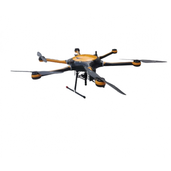
The ATHL9606 UAV multispectral LiDAR integrated system, introduced as Optosky Technologies' latest third-generation UAV multispectral imager, incorporates cutting-edge LiDAR technology. This advanced system features a series of compact, lightweight UAV-mounted micro multispectral imagers, including a hexacopter known for its stability and equipped with a stable gimbal. It integrates a hyperspectral imager, LiDAR module, large-capacity storage system, GPS navigation, ground receiving workstation, and ground control system.Expanding its capabilities in multispectral imaging, the ATHL9606 utilizes a line-scanning LiDAR to capture precise surface elevation data, enabling highly accurate orthorectification of images and providing detailed stereoscopic information about objects. Integrated spectral data analysis opens new avenues for research exploration.
Availability: In Stock
UAV Multispectral lidar Machine
Product Code: ATHL9606
application
Description
The ATHL9606 UAV multispectral LiDAR integrated system, introduced as Optosky Technologies' latest third-generation UAV multispectral imager, incorporates cutting-edge LiDAR technology. This advanced system features a series of compact, lightweight UAV-mounted micro multispectral imagers, including a hexacopter known for its stability and equipped with a stable gimbal. It integrates a hyperspectral imager, LiDAR module, large-capacity storage system, GPS navigation, ground receiving workstation, and ground control system.Expanding its capabilities in multispectral imaging, the ATHL9606 utilizes a line-scanning LiDAR to capture precise surface elevation data, enabling highly accurate orthorectification of images and providing detailed stereoscopic information about objects. Integrated spectral data analysis opens new avenues for research exploration.
Equipped with a high-resolution solid-state scanning LiDAR module, hyperspectral imager, and high-precision inertial navigation, the ATHL9606 system generates real-time true-color point clouds. A single flight mission can swiftly acquire point cloud data exceeding 2 km².
Optosky's series of UAV multispectral LiDAR machines are tailored for real-time measurement of spectral information from vegetation, water bodies, soils, and other land features, capturing spectral images for detailed analysis. This analysis establishes correlations with physicochemical properties of plants, facilitating studies such as plant classification and growth assessment.In the field of UAV multispectral LiDAR machines, current technical trends highlight advancements in spectral resolution and broadening applications in precision agriculture, environmental monitoring, and resource management. These machines are pivotal in advancing research capabilities, offering in-depth insights into natural and agricultural environments.
Features
- 6 multispectral channels
- 48° × 36.8° field of view
- 4096 x 3000 resolution
- Strip filter structure
- Operating altitude: 50-500m (recommended at 100m)
- Solid-state LiDAR
- Range: 1-150m
- Height measurement error: ±2cm
- Onboard I7 computer (up to 2TB storage)
- 1.5m large multi-rotor UAV
- Extended flight time: ~45 minutes
ATHL9606 | |
Flight System | |
Flying platform | Customized version of long-time high-load large 6-rotor UAV |
Ptz | Three-axis brushless DC motor high stability gimbal |
Number of rotors | 6 rotors |
Take-off and landing mode | vertical takeoff and landing |
Wheelbase | 1500 mm |
Maximum load | 6 Kg |
Maximum ceiling | 5000 m |
Size | 1650 X 1410 X 500 mm |
Gps | 1.5 m |
Modify imaging parameters remotely | NO |
Endurance flight time | >45 minutes |
Ground station working distance | 5 Km |
6-band multi-band imager | |
Aisle | 6 channels |
Resolution | 4096×3000 |
Detector native resolution | 4096 x 3000 |
Detector original pixel size | 3.45 μm x 3.45 μm |
Field of view | 48°×36.8° |
Bit depth | 12bit |
Center wavelength | Blue:450nm (bandwidth:35nm) |
Green:555nm(bandwidth:27nm) | |
Red:660nm (bandwidth:22nm) | |
Red:720nm (bandwidth:10nm) | |
Red:750nm (bandwidth:10nm) | |
Near infrared:840nm (bandwidth:30nm) | |
Frame rate | 31fps |
Data output interface | USB 3.0, |
Detector power supply | USB powered, 3.6 W |
Volume | 8.2 x 6.7 x 6.45cm |
Weight | <580 g |
Operating temperature | -20 ~ 50°C |
Storage temperature | -20 ~ 50°C |
Lidar | |
Radar work | TOF time-of-flight ranging method |
Laser wavelength | 1550nm, eye safety level 1 |
Ranging speed | 500,000 points/second, up to 1 million points/second (depending on distance) |
Number of scan lines | 1750 line |
Field of view | Horizontal 15°° |
Angular resolution | Horizontal 0.009°° |
Scanning frequency | 500 Hz |
Height measurement range | 1~300 m, maximum 600 m |
Laser return mode | multiple echoes |
Height measurement error | <20mm |
Weight | 1.5kg |
Reliability | |
Range of working temperature | -10 ~ 45℃ |
Storage temperature range | -20 ~ 65℃ |
Working humidity range | ≤85% RH |


