Your shopping cart is empty!
UAV Fluorescence Imaging Oil Spill Remote Sensing System


Applications


Availability: In Stock
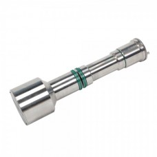
UAV Fluorescence Imaging Oil Spill Remote Sensing System
Product Code: ATE5000
application
Description
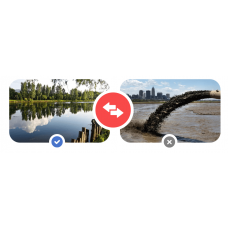
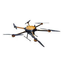
The ATE5000 UAV Fluorescence Imaging Oil Spill Remote Sensing System by Optosky is an advanced solution for detecting oil spills and gas emissions. It features a high-performance oil spill detector, gas detector, stable quadcopter UAV, large-capacity storage, wireless imaging, and ground control system, providing a new way to monitor oil spills and ship-related pollutants.Using advanced remote sensing, the system efficiently detects oil spills and atmospheric pollutants, improving environmental monitoring's automation and accuracy. Its real-time data management supports environmental protection and emergency response.The ATE5000 offers precise inspection for oil spill and gas detection in rivers, lakes, and oceans. Ground software receives real-time data, triggers alarms for oil spills, and generates inspection reports, supporting both automated and manual flight operations.
Features
Features
- lThe system uses advanced laser-induced fluorescence technology with microsecond response time, detecting oil spills below 50m altitude and monitoring CO2 and SO2 emissions.
- lIt integrates flight control for oil spill and gas inspections, with remote or cloud-based data viewing and control.
- lIt supports automated area scanning, manual leak scanning, and data export via an app.
- lReal-time displays oil spill, gas status, coordinates, and time.
- lWireless transmission supports up to 15km.
- lThe system provides 24/7 sea surface monitoring, unaffected by darkness or fog, ideal for emergency oil spill and gas detection.
| Optosky Physical Parameters | |
| Dimension | 152mm*143mm*115mm |
| Measuring host | |
| Measurement object | petroleum, motor oil, diesel oil, gasoline, kerosene, etc |
| Measure oil film thickness | The thickness of 1 um can be measured |
| Max endurance flight | 1.5 hours |
| Scanning area | 1-20km^2 |
| Single measurement area | Round, 10 mm in diameter |
| GPS positioning accuracy | 1m |
| Working time | Work day and night |
| Remote control distance | 10 Km |
| Data transfer download distance | 1 Km |
| Environmental requirements | -5—45℃;Relative humidity<90%,No condensation |
| Data transfer download speed | 1Mbps/s |
| The UAV’s own weight | 6 Kg |
Oil Spill Detection Module | ||
Detection Target | Detects all types of oil | |
Detection Principle | Laser Induced Fluorescence (LIF) technology | |
Performance | All-weather oil spill detection, recognition, and alarm, with remote alarm capability | |
Sensitivity | ≤20um | |
Minimum Target Radial for Oil Film Area Detection | ≤5m | |
Response Speed | ≥0.1s | |
Detection Distance | Daytime >50m, nighttime >50m | |
Coverage Area | 5km line-of-sight distance | |
Detection Frequency | ≤10s per detection | |
Gas Detection Module | ||
Detection Target | Typical ship atmospheric pollutants: CO2, SO2 | |
Detection Principle | Non-dispersive infrared absorption spectroscopy, electrochemical detection | |
Range | SO2 | 0-1000ppm |
CO2 | 0-10000ppm | |
Response time | ≤30S | |
System | ||
Satellite positioning | GPS | |
Data storage | SD card | |
Power supply voltage | 24V | |
Output data | Oil spill status, gas concentration, GPS coordinates, time, temperature, etc. | |
Data transmission method | WiFi/4G/5G | |
Operating temperature | -20℃ to+55℃ | |
Operating humidity | 95% RH, no condensation | |
Enclosure protection level | IP54 | |
Android software | ||
Basic functions | Flexible settings for UAV and fluorescence oil spill gas detection parameters Real-time display of oil spill, gas status, and alarm data Supports path inspection and automatic cruising One-click export of test reports after mission completion | |