Your shopping cart is empty!
Airbone Hyperspectral Imaging


application
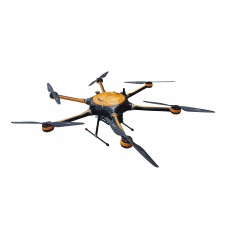
ATHL9010 series is the 3rd generation hyperspectral imager integrated LiDAR system. This new series feature compact and light.
It consists of eight main parts of six-rotor UAV, high-stable cloud platform, hyperspectral imager, LiDAR, big memory storage, GPS navigation system, ground receiver station, and ground control system.
It depends on linear LiDAR to get surface elevation, images ortho-rectification, and 3D object attitude, whose LiDAR data and spectral data are being combined to analysis open up new research way.
ATHL9010 integrated high-precision hyperspectral imager and high-resolution LiDAR, which generates field true color point cloud, one fly can get as fast as >2 km2 point cloud data.
From real-time measure spetral data collection to spectral images analysis, and final physicochemical properties calculation. They've widely applied to plants classification and growth assessment.
| Detector | |
| Type | CCD |
| Effective pixels | 1920 × 1200 |
| Range | 350~1100 nm |
| Dynamic range | 66 dB |
| Bit Depth | 12 bit |
| Mode | Software Binning or hardware binning(software setup) |
| PC | I7,16G ,512GB,Max 2TB |
| Optosky Optical Parameters | |
| Spectral Range | 400~1000 nm (customization option ) |
| Spectral Resolution | <1.5 nm |
| FOV | 14.6° |
| Smile | <1/3 pixel |
| Keystone | <1/3 pixel |
| Lens FL | 35mm |
| Slit size | 30μm |
| NA | 0.2(F/2.4) |
| Optical bench | PG imaging spectrometer |
| Frame Rate | 130 Hz |
| Image Resolution | 1920×1080 |
| Imaging mode | Push broom |
| Resolution Before Binning | 1920(spatial-axis)×1080(spectral-axis) |
| Resolution After Binning | 480(spatial-axis)×270(spectral-axis) |
| Optosky Electrical Parameters | |
| Power supply | 12V,5W |
| Storage Temp. | -20 ~ 65℃ |
| Operating Temp. | -10 ~ 45℃ |
| Working humidity | ≤85% RH |
| Interface | USB3.0 |
| Load PC | Intel I7 CPU 16G |
| PC Hard drive | 512 GB SSD,Max 2T |
| Optosky Visible camera | |
| Resolution | 2-mega pixels |
| Frame Rate | 20 FPS |
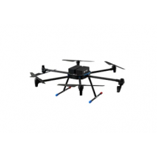
| UAV System | |
| Drone | Luxury Six Rotor Drone customized with load hour > 45 minutes |
| Cloud Platform | High stable Cloud platform driven by 3-Phase BLDC Motor |
| Rotor No. | Six Rotors |
| Lift | Take off and land vertically |
| Wheelbase | 1500 mm |
| Max base | 6 Kg |
| Max altitude | 5000 m |
| Drone size | 1650 X 1410 X 500 mm |
| GPS accuracy | 0.5 m |
| Flight duration | >45 minutes |
| Ground control distance | 10 Km |
| Remote change imaging parameter (Y/N) | Yes |
| LiDAR | |
| Principle | The LIDAR system uses the time of flight(TOF) to measure the distance |
| Laser | 1550nm Eye-safe |
| Speed | 500,00 points per second, max 1,000,000 points per second depends on the distance |
| Scan Line | 1750 lines |
| FOV | Horizontal 15° |
| Angular resolution | Horizontal 0.009° |
| Scan rate | 500 Hz |
| Elevation | 1~300 m,Max 600 m |
| Laser return mode | Multiple returns |
| Altitude deviation | <20 mm |
| Weight | 1.5 Kg |
| Software | |
| Basic Functions | Flexible to set exposure time, gain, speed, dynamic real-time images and curves |
| Focus adjust | Dynamic real-time image obtained through precision focus adjustment can avoid human visual focusing error |
| Software Functions | Data acquire software can real-time shows images and curves Transmission and reflectance measure mode set exposure time, speed in flexible Standard in-built Library and self-built library Others like images cut and identify spectrum |
lRange: 400~1000nm
lSpectral Resolution:<1.5 nm
lFOV: 23.5°@f=35mm (Lens changeable)
lIFOV:0.9 mrad@f=35mm (Lens changeable)
lFlight height: 50~1000 m, recommend height 100m
lPC Intel Core i7 with max. 2T memory reach up to 100 hours images data
l1.5m multi-wing drone with heavy-load or extendable
lLong flight time about 45 minutes, large cruise area
- Monitor Agriculture: plant diseases and insect pest, disaster, categories ID etc
- Forestry: Tree categories identification, Phytomass, nutrient elements, forest health etc
- Water Environment: Water quality parameters, water waste spatial distribution and migration analysis
- Soil pollution: heavy metal waste
- Minerals: Mineral mapping, ingredients explore, metallogenic prognosis etc
- City geological substances classification and identification
- And educational research, smart agriculture, target recognition, military anti-camouflage
What is Hyperspectral Imaging Camera?
Hyperspectral imaging Camera, or imaging spectroscopy, combines the functions of imaging camera and spectroscopy. A hyperspectral camera acquires the spectrum for each pixel in an image of the scenes.
What does Hyperspectral Imaging Camera used for?
Hyperspectral Imaging Camera are used for applications in astronomy, agriculture, molecular biology, biomedical imaging, geosciences, physics, environment,and monitoring. Hyperspectral imaging camera takes pictures of objects spectrum with unique 'fingerprints', it enable identification of the materials. Like spectral fingerprint of oil helps geologists locate new oil fields.
What does Hyperspectral Imaging Camera tell you?
The hyperspectral imaging provides much more color information in details than a normal camera,which leads to differentiate from objects in the scene. Hyperspectral imaging is used to find objects, identify materials, or detect processes.
How much does Hyperspectral Imaging Camera cost?
OPTOSKY manufactures hyperspectral imaging camera 400-1000nm prices range USD45,000~49,800.
How to choose a Hyperspectral Imaging Camera?
Compare FOV,spatial dimensions, weight,optical performance,size, and cost etc.
Where to buy Hyperspectral Imaging Camera?
Buy from local distributor of OPTOSKY,online shopping or inquire us.
Why Chosse Optosky Hyperspectral Imaging Camera?
1.Optosky F2.4, FOV is larger than that of competitors
2.Spatial dimension 14mm
3.Lightweight 1500 g, 950g, 650g
4.High optical performance
5.Compact size:300x70 x70mm;300x60x60mm;270x50x50mm