Your shopping cart is empty!
UAV NIR Hyperspectral Imager


Availability: In Stock
UAV NIR Hyperspectral Imager
Product Code: ATH9010-17/25
application
Description
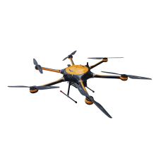
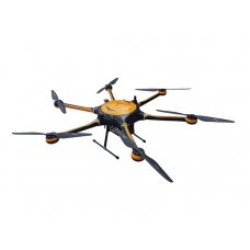
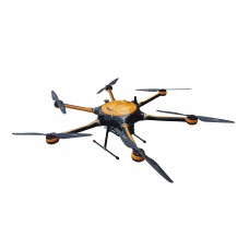
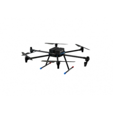
The ATH9010-17 and ATH9010-25 series UAV near-infrared hyperspectral imagers are the third-generation UAV hyperspectral imagers launched by Optosky. They are a series of small, lightweight UAV-borne micro-hyperspectral imagers. The imager consists of a six-rotor high-stability drone, a high-stability gimbal, a hyperspectral imager, a large-capacity storage system, a wireless image system, a GPS navigation system, a ground receiving workstation, a ground control system, etc.
ATH9010 series UAV hyperspectral adopts push-broom imaging method. The band range of ATH9010-17 is 900-1700nm, the number of spectral bands is 512, and the number of spatial bands is 640; the band range of ATH9010-25 is 1700-2500nm, and the spectrum The number of bands is 256 and the number of spatial bands is 320.
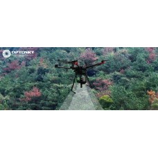
The ATH9010 series UAV hyperspectral imager can be used to measure the spectral information of plants, water bodies, soil and other surface objects in real time, and obtain spectral images. By analyzing the spectral images, it can establish a relationship with the physical and chemical properties of plants, etc., and be used for plant classification. Research on plant growth conditions, etc. The entire system is compact in design, and the main host of the imaging spectrometer has high spectral resolution. It also adopts an external push-broom imaging method. It can form an independent measurement system with a field rotating platform and an indoor linear scanning platform. It can also be mounted with a drone for aerial remote sensing operation.
Features
- Band range: 900~1700nm or 1700~2500nm
- High spectral resolution: better than 4.9 nm
- Transmission grating spectroscopy, pushbroom imaging;
- Wide field of view:18.28°@f=35mm (depending on the lens)
- Instantaneous field of view: 0.008°@f=35mm (related to the lens)
- Flight altitude: 50~1000 meters, recommended 100m
- Supports up to 2T storage and can store up to 100 hours of imaging data
- 1.5m wheelbase large multi-rotor UAV with high load capacity and strong scalability;
- Ultra-long flight time: about 45 minutes, large cruising area
The ATH9010-17 and ATH9010-25 series UAV near-infrared hyperspectral imagers are the third-generation UAV hyperspectral imagers launched by Optosky. They are a series of small, lightweight UAV-borne micro-hyperspectral imagers. The imager consists of a six-rotor high-stability drone, a high-stability gimbal, a hyperspectral imager, a large-capacity storage system, a wireless image system, a GPS navigation system, a ground receiving workstation, a ground control system, etc.
ATH9010 series UAV hyperspectral adopts push-broom imaging method. The band range of ATH9010-17 is 900-1700nm, the number of spectral bands is 512, and the number of spatial bands is 640; the band range of ATH9010-25 is 1700-2500nm, and the spectrum The number of bands is 256 and the number of spatial bands is 320.
The ATH9010 series UAV hyperspectral imager can be used to measure the spectral information of plants, water bodies, soil and other surface objects in real time, and obtain spectral images. By analyzing the spectral images, it can establish a relationship with the physical and chemical properties of plants, etc., and be used for plant classification. Research on plant growth conditions, etc. The entire system is compact in design, and the main host of the imaging spectrometer has high spectral resolution. It also adopts an external push-broom imaging method. It can form an independent measurement system with a field rotating platform and an indoor linear scanning platform. It can also be mounted with a drone for aerial remote sensing operation.
Features
- Band range: 900~1700nm or 1700~2500nm
- High spectral resolution: better than 4.9 nm
- Transmission grating spectroscopy, pushbroom imaging;
- Wide field of view:18.28°@f=35mm (depending on the lens)
- Instantaneous field of view: 0.008°@f=35mm (related to the lens)
- Flight altitude: 50~1000 meters, recommended 100m
- Supports up to 2T storage and can store up to 100 hours of imaging data
- 1.5m wheelbase large multi-rotor UAV with high load capacity and strong scalability;
- Ultra-long flight time: about 45 minutes, large cruising area
ATH9010-17 | ATH9010-25 | |
Hyperspectral Imager | ||
Band range | 900-1700nm | 1700-2500nm |
Band resolution | 4.7nm | 4.8nm |
Data interface | USB3.0 | |
Imaging method | Push-scan imaging | |
Resolution | 640 (Spatial Dimension)×512 (Spectral dimension) | 320 (Spatial Dimension)×256 (Spectral dimension) |
Resolution | 320 (Spatial Dimension)×256 (Spectral dimension) | 480 (Spatial Dimension)×270 (Spectral dimension) |
Maximum frame rate | 85 Hz | 130 Hz |
onboard computer | Intel I7 CPU, 16GRAM | |
Onboard storage | 512 GB SSD,up to 2T | |
Power supply | 12V,5W | |
Reliability | ||
Operating Temperature Range |
| |
Storage Temperature Range | -20 ~ 65℃ | |
Operating Humidity Range | ≤85% RH | |
Optical parameters (customisable) | ||
spectral line bending | <1/3 pixel | |
Spectral distortion | <1/3 pixel | |
lens focal length | 35mm | |
Field of view | 15.2° | 14.6° |
slit width | 30μm | |
System numerical aperture | 0.19(F/2.6) | 0.2(F/2.4) |
Optical path design | Fully transmissive lens, scientific dark and light focusing | |
Sensor | ||
Sensor type | CCD | |
Data bit depth | 16 bit | |
Acquisition method | Software Binning or Hardware Binning | |
Software | ||
Basic Functions | Flexible setting of exposure, gain and speed, dynamic display of real-time hyperspectral images and hyperspectral curves; | |
Focusing | Dynamic real-time display of hyperspectral images, scientific dark and light focusing, to avoid human visualisation of focusing errors | |
Software system | Data acquisition software, can real-time dynamic display of hyperspectral images and hyperspectral curves; can provide transmission, reflection and other measurement modes, can be flexibly set the exposure time, speed and other parameters, comes with a spectral library and user self-recorded libraries, can be realised image cropping, spectral recognition and other functions | |