Your shopping cart is empty!
VIS-NIR Hyperspectral lmager


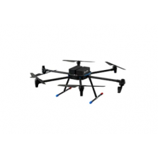
The ATH9010Z series hyperspectral drone, launched by Optosky, is the third generation of UAV-based multispectral imaging instruments with a wide wavelength range. It comprises 2-3 compact, lightweight hyperspectral imaging devices of different wavelength bands, integrated with high-performance wavelength fusion algorithms to achieve wide-band hyperspectral imaging. The system consists of a hexacopter with high stability, a high-stability gimbal, hyperspectral imaging devices, a large-capacity storage system, a wireless image system, a GPS navigation system, a ground receiving workstation, and a ground control system.
Availability: In Stock
VIS-NIR Hyperspectral lmager
Product Code: ATH9010Z
application
Description
The ATH9010Z series hyperspectral drone, launched by Optosky, is the third generation of UAV-based multispectral imaging instruments with a wide wavelength range. It comprises 2-3 compact, lightweight hyperspectral imaging devices of different wavelength bands, integrated with high-performance wavelength fusion algorithms to achieve wide-band hyperspectral imaging. The system consists of a hexacopter with high stability, a high-stability gimbal, hyperspectral imaging devices, a large-capacity storage system, a wireless image system, a GPS navigation system, a ground receiving workstation, and a ground control system.
The ATH9010Z-4-17 and ATH9010Z-4-25 models use Optosky's self-developed hyperspectral imaging devices and optical modules, providing clear imaging with low noise. The ATH9010Z series also includes high-performance hyperspectral data acquisition and processing software.
The ATH9010Z-4-17 and ATH9010Z-4-25 hyperspectral drones can be used for real-time measurement of the spectral information of plants, water bodies, soil, and other ground objects, obtaining spectral images. By analyzing these spectral images, relationships with the physicochemical properties of plants can be established, which is useful for plant classification, plant growth status, and other research areas. The entire system is compact in design, with the main imaging spectrometer offering high spectral resolution. It uses an external push-broom imaging method and can form an independent measurement system with a field rotary platform and an indoor linear scanning platform, or be mounted on a UAV for aerial remote sensing operations.The system is particularly useful for UAV-Based Forest Health Monitoring, agriculture drones, food security, and other applications requiring multispectral imaging.
Features
- Wavelength range: 380~1700nm or 380~2500nm
- Wide wavelength range, high spectral resolution
- Transmission grating, push-broom type
- Low-temperature cooled camera
- Flight altitude: 50~1000 meters, recommended 100 meters
- Onboard I7 computer, supports up to 2TB storage, can store up to 100 hours of imaging data
- Large multi-rotor UAV with a 1.5m wingspan, high payload, highly expandable
- l Ultra-long flight time: about 45 minutes, covering a large area during cruise
ATH9010Z-4-17 | ATH9010Z-4-25 | |
Hyperspectral Imager | ||
Data Interface | USB 3.0 | USB 3.0 |
Imaging Method | Push-broom imaging | Push-broom imaging |
Spectral Range | 380-1700nm | 380-2500nm |
Best Spectral Resolution | Visible spectrum: <1.5nm | Visible spectrum: <1.5nm |
Near-infrared spectrum: <4.5nm | Near-infrared spectrum 1: <4.5nm | |
Near-infrared spectrum 2: <9.7nm | ||
Number of Bands (Before Binning) | Visible spectrum: 1920 (spectral) × 1200 (spatial) | Visible spectrum: 1920 (spectral) × 1200 (spatial) |
Near-infrared spectrum: 640 × 512 | Near-infrared 1: 640 × 512 | |
Near-infrared 2: 320 × 256 | ||
Number of Bands (After Binning) | Visible spectrum: 300 (spatial) × 480 (spectral) | Visible spectrum: 300 (spatial) × 480 (spectral) |
Near-infrared spectrum: 640 × 512 | Near-infrared 1: 640 × 512 | |
Near-infrared 2: 320 × 256 | ||
Maximum Frame Rate | 270 Hz | 80 Hz |
Sensor Type | CMOS, InGaAs | CCD, InGaAs, InGaAs II |
Data Bit Depth | 12-bit, 14-bit | 12-bit, 14-bit |
Acquisition Method | Software Binning or Hardware Binning (software selectable) | Software Binning or Hardware Binning (software selectable) |
Onboard Computer | Intel I7 CPU, 16GB RAM | Intel I7 CPU, 16GB RAM |
Onboard Storage | 512 GB SSD, up to 2TB | 512 GB SSD, up to 2TB |
Visible Light Camera | 5 megapixels | 5 megapixels |
Power Supply | 12V, 3A | 12V, 5A |
Reliability | ||
Operating Temperature Range | ||
Storage Temperature Range | -20 ~ 65°C | -20 ~ 65°C |
Operating Humidity Range | ≤85% RH | ≤85% RH |
Software | ||
Basic Functions | Flexible exposure, gain, and speed settings; dynamic display of real-time hyperspectral images and spectra; | Flexible exposure, gain, and speed settings; dynamic display of real-time hyperspectral images and spectra; |
Focus | supports transmission, reflection, and other measurement modes; adjustable exposure time, speed, and other parameters; includes spectrum library and user-defined libraries; enables image cropping and spectrum recognition | supports transmission, reflection, and other measurement modes; adjustable exposure time, speed, and other parameters; includes spectrum library and user-defined libraries; enables image cropping and spectrum recognition |
Software System | Dynamic real-time display of hyperspectral images for precise focusing, avoiding manual visualization errors | Dynamic real-time display of hyperspectral images for precise focusing, avoiding manual visualization errors |
Data acquisition software with real-time display of hyperspectral images and spectra; supports various measurement modes and parameters; includes spectrum library and user-defined libraries | Data acquisition software with real-time display of hyperspectral images and spectra; supports various measurement modes and parameters; includes spectrum library and user-defined libraries |


-228x228.jpg)