Your shopping cart is empty!
Wideband Hyperspectral Imager


Description
Availability: In Stock
Wideband Hyperspectral Imager
Product Code: ATH1010-4-17
application
Description
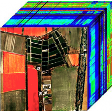
The ATH1010-4-17 is a compact, lightweight wide-band hyperspectral imager compatible with various drones. It offers high spatial and spectral resolution, along with a wide imaging range. The system includes an imaging lens and a hyperspectral sensor using transmission grating technology, providing excellent aberration characteristics and clear, low-noise images with high performance CCD imaging devices. Its cylindrical design makes it ideal for multirotor drones.
This imager is ideal for real-time spectral measurement of plants, water, and soil, enabling research in plant classification and growth monitoring. The system features high spectral resolution and uses external scanning imaging, which can be paired with rotating or linear scanning platforms for independent measurements. It can also be mounted on drones for aerial remote sensing applications.
Features- Wavelength Range:400–1700nm.
- Hyperspectral resolution: 1.5nm at 546nm, 4.6nm at 1128nm.
- Spectral path: Holographic transmission grating.
- Maximum FOV: 31.7°.
- Minimum instantaneous FOV: 1.2mrad.
- Exceptional imaging performance.
- Powerful image compression algorithm.
- Compact size: 280mm × 150mm × 75mm.
- Lightweight: <1700g.
- No mechanical scanning, high reliability.
Performance | Parameters | |
No | Model | ATH1010-4-17 |
1 | Spectral Range | 400~1700nm |
2 | Best Spectral Resolution | Visible/NIR: 1.4nm, SWIR: 3.5nm |
3 | Max Spectral Channels | Visible/NIR: 1920, SWIR: 640 |
4 | Max Spatial Channels | Visible/NIR: 1200, SWIR: 512 |
5 | Detector | SCMOS+InGaAs |
6 | Detector Native Resolution | Visible/NIR: 1920×1200 SWIR: 640×512 |
7 | Pixel Bit Depth | Visible/NIR: 12bit, SWIR: 14bit |
8 | Max Frame Rate | 156fps |
9 | Scanning Method | External scanning |
9 | Numerical Aperture | Visible/NIR: F/2.4, SWIR: F/2.0 |
10 | Data Output Interface | USB3.0 |
11 | Field of View | Visible/NIR: 11.4°@f=35mm, SWIR: 12.5°@f=35mm |
12 | Instantaneous Field of View | Visible/NIR: 0.167mrad@f=35mm SWIR: 0.418mrad@f=35mm |
13 | Focal Length | 25mm, 35mm optional |
14 | Dimensions | 280mm×150mm×75mm |
15 | Weight | 1700g |
16 | Operating Temperature | -20~55°C |
17 | Storage Temperature | -30~70°C |


-228x228.jpg)